| |
 |
| |
|
| |
M
e n u e |
| |
|
| |
|
| |
|
| |
|
|
| |
 |
|

Greenland: Kayaking in west Greenland |
|
| |
|
|
Author: Markus
Ziebell, Photos: Markus Ziebell
Translated by: Carmen Chaplin
This trip was made in July/August 2001
Dieser Reisebericht ist auch in deutscher Sprache verfügbar. Bitte folgen Sie diesem Link |
| |
Kayaking in west Greenland
A 23-day solo kayak tour through the icy world of the icebergs of Disko
Bay.
|
|
|
| |
Padddling heats you up and, despite a water temperature of just six degrees
Celsius, you are able to take a short bath between the chunks of ice.
However, you are soon driven back to the shore by foot cramps. |
| |
The Scandinavian Airlines >Dash 7< is getting ready to land at Ilulissat at
about 22.30 p.m. It is the beginning of July and, since we
are about 300 kilometers north of the polar circle, there is a glorious
midnight sun, so I’m able to savour the first glimpse of the Isfjord as it
appears below me. The Kangerdluaq glacier is one of the astest glaciers of
the northern hemisphere, it advances about 30 meters a day. Thus, huge
amounts of large and small icebergs are formed which fill the whole fjord
and eventually drift into Disko Bay. From there, they slowly travel south
on the ocean current. Some of these icebergs drift across the ocean for up
to 20 years and reach regions as far south as New York. Even the iceberg
that was rammed by the Titanic in 1912 probably originated from this bay
and once started out as innocent snow on an ice sheet here.
I am picked up at the airport by Silver, an Italian, who moved here many
years ago and who runs the travel agency >Tourist Nature<, and he takes me
to a camp site south of Ilulissat that's only meters away from the Isfjord.
There, I revel in the indescribable view of Disko Bay and its many icebergs until
long after midnight.
|
| |
|
|
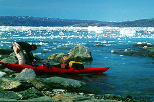
Due to an offshore shoal, the icebergs pile up in the Isfjord until they
have thawed enough in order to start their long journey.
|
|
| |
Silver and I spend the next day planning my exact route, buying food
supplies and visiting the town. Ilulissat, with its approx. 4000
inhabitants the third largest town in the country, depends on fishing and,
more than most other towns, tourism. But even though modern technology has
entered every area of life here, the traditional ways of the Inuit are
nevertheless still present everywhere. That's made most obvious by the many
sled dogs that are chained up in every open space. Due to the odd stray dog
here and there, I have to keep an eye on my food supplies, which I store in
waterproof bags right next to my tent. Silver and I have arranged for a
motorboat to take me to Ata the next day, 60 kilometers north from here.
There is a small camp up there with some kayaks, one of which is reserved
for me.
Stranded in the Mudderbugten - The next morning, there is dense fog. I
still pack my bags early and meet Silver for an 8 a.m. breakfast in a small
cafe. Naturally, a crossing is out of the question in this weather. So we
have some time and he tells me about their problems with fog. Disko Bay may
be one of the sunniest and warmest places in Greenland, but as there's so
much ice here, fog develops very quickly when rain-bearing air masses move
in from the sea. Normally, it only stays for a short while, but a few years
ago, Silver's business suffered badly when the fog didn't lift for 3 long
weeks in July, the high season.
|
| |
Luckily, today the fog lifts after just two hours, so Jens, a tall, lean
Inuit, and I are able to load the small boat and put to sea at noon. The
visibility is excellent again, and I make myself comfortable lying down
between my bags. With great skill and speed, Jens steers a zigzag course
between the icebergs. Several times, seals appear in front of us and
quickly disappear into the depths again. Half an hour later, we reach
virtually open water. At such high speed, the boat crashes into every wave
and the bags and I are thrown into the air each time, only to drop down
hard an instant later. I desperately try to cling on to something. Jens,
however, seems to rather enjoy the constant bouncing. After a short while,
he slows down the boat, not because that might make me feel better, but
because the motor is in trouble and finally sputters to a halt. It
starts again after several attempts, but that only lasts for a few hundred
meters and the motor soon packs up again. We take out the spark plugs to dry them,
let the motor spin and put everything back together again. Without success.
We repeat this game several times. Finally, we manage to get the motor to
work, although it doesn't run properly and won't accept the petrol
normally. We carry on at a snail's pace. Two more times the motor stops,
and two more times we take everything apart and get it to work again. We
are riding along the shallow coast by the time the motor goes dead for the
last time, and now it won't spin anymore. Possibly due to piston seizure.
We drop the little anchor and use it to pull ourselves towards the shore
bit by bit for the last 200 meters. Jens tries to make radio contact with
the station in Ata. Without luck.
|
| |
|
|
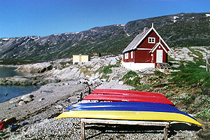
Today, the old, abandoned settlement of Ata serves as a base for many
outdoor activities in the region, and it's the starting point of my trip.
|
|
| |
Jens points out an antenna on a hilltop just a few kilometers away. That's
where we might find the station, so we set off for it on foot. A few
minutes later, we see a fisherman pass by in his motorboat in the distance.
We wave our coats to attract his attention and he actually sees us and
comes over. I glean from the conversation that we have completely lost our
way. Ata Station is on another island, around 40 kilometers east of here.
The fisherman is willing to tow our boat to the Mudderbugt, which offers
more shelter. Then he takes us to the southern tip of Arve Prinsens Ejland,
where Silver, who happens to be in the vicinity with a bigger boat when he
receives our radio call, is going to meet us. Around midnight, twelve hours
after having started, we finally arrive at Camp Ata, the point of departure
for my kayak trip. It's been an eventful day.
Eqip Sermia - The next morning, I'm up early in anticipation and arrange my
gear on the beach. As an alternative to a Hazle Explorer (single), Silver
offers me a double by Prijon, as he thinks a narrow single probably won't
be big enough to accommodate all of my gear. But apart from the slightly
bulky sleeping bag, which ends up in a waterproof bag at the stern, I
manage to stow everything in the lockable hatches. Silver is a little
concerned because nobody has been away this long with one of his boats
before. Especially not on their own. So we agree that I will phone from one
of the Inuit settlements. And when I have fitted out my cockpit with a GPS,
a compass, a radio set and a shipping radio set, he is quite surprised that
I'm so well-equipped and seems reassured.
As soon as I have heaved the kayak, which by now weighs a hefty 100
kilograms, into the water, and have taken my seat in the comfortable boat,
the indescribable feeling of freedom and joyful anticipation that I often
get at the beginning of a trip, slowly grows inside of me. Thanks to its
weight, the narrow boat is very stable in the water, and so I am able to
enjoy the sun, which is being reflected in the water, right from the start. |
| |
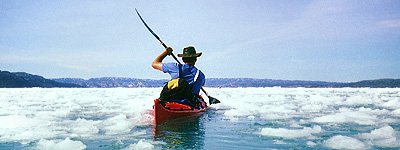
When the ice breaks off from the glacier's edge, most of it splinters into
small floes. But although paddling is laborious here, it's problem-free. |
|
|
| |
On my first day, I decide to cover the 30 kilometers to the Eqip glacier.
From the outset, I come across small icebergs which drift towards me in
bizarre shapes, and a few hours later, I reach the first fields of ice. To
begin with, there are only scattered fragments and the odd larger floe, but
they soon form a dense blanket, so that I end up having to cut a channel
through the ice with my boat.
Again and again, I see areas of open water with numerous stretches of
broken ice in between. I land at a large floe to get a better view. The
white colossus may look like snow, but its surface turns out to be so hard
and slippery that I am forced to crawl on all fours. I tie the boat to an
ice screw, which I carry with me in case I need it to secure the tent in an
emergency. But there is no chance of calmness during this break, as even
this chunk, which measures about 20 meters, rolls alarmingly, and as a
result, I only stay a few minutes and am soon on my way. Even before, I had
noticed that these icebergs and chunks of ice are in constant danger of breaking up and may turn at any time. In contrast to frozen sea ice, which
has an even thickness, these masses are made up of unevenly formed ice, of
which only a seventh is visible. The ice slowly thaws above as well as
below the water, and the centre of gravity shifts with time until the
iceberg tips over. Unfortunately, I'm not able to predict when this might
happen.
|
| |
|
|
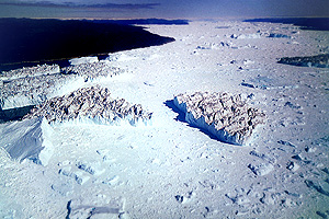
It's quite obvious that the ice is being carried off by a current that
emerges from underneath the glacier. |
|
| |
Having paddled for seven hours, I reach a sandy beach east of the glacier's
breakoff edge. I had originally planned to enter the sheltered lagoon, but
since I'm faced with a strong current that's coming at me with the outgoing
tide, I pull the boat onto the beach, which is strewn with chunks of ice. I
pitch my tent above a rocky cliff among some low shrubs. From now on, every
time I land, I will have to unload the boat and carry it to a safe place,
where it can't be flooded.
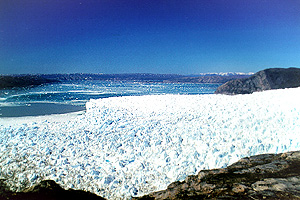
The next day, I investigate the ridge of hills that rise up as high as 600
meters right on the edge of the glacier. There, I am treated to
breathtaking views across the glacier, the bay and the distant islands.
|
|