| |
 |
| |
|
| |
M
e n u e |
| |
|
| |
|
| |
|
| |
|
|
| |
 |
|

The Yukon: In the Footsteps of the Gold Rush |
|
| |
|
|
 |
|
Author: Markus Ziebell, Photos: Markus Ziebell
Translated by: Carmen Chaplin
This trip was made in Mai-August 1996
Trip made by: Peter Wallek and Markus Ziebell
Dieser Reisebericht ist auch in deutscher Sprache verfügbar. Bitte folgen Sie diesem Link |
| |
The Yukon:
In the Footsteps of the Gold Rush
Through the Inland Passage, along the Chilkoot Trail and 3.500 kilometersdown the Yukon River to the Bering Sea. |
|
| |
| On August 16th 1896, Jim Shookum, Charlie Dawson and George Carmack came upon rich gold deposits by the Klondike River. They named the stream Bonanza Creek, which then made history as the world's richest gold find. The following years saw a hitherto unprecedented run on the goldfields of the Yukon River and its tributaries. A hundred years later, we set off to follow in the footsteps of these adventurers. |
|
| |
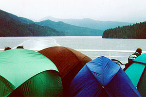
It is noon, and we're among the first to take possession of a place at what seems like the world's longest camping site. We have put up our tent on the afterdeck of the ferry that is taking us through the Inland Passage, from Bellingham south of Vancouver to Skagway in Alaska.
|
| |
|
|
Instead of securing our tent with pegs, we tie it to the ship's rail on one
side and use sticky tape on the ship's metal floor on the other. Thus, by
the time we depart, a small city of over twenty tents has sprung up on two
decks.
|
|
| |
Most of the passengers are young Americans who are going to Alaska in the summer months for work. There are plenty of opportunities to meet people during the 3-day trip, particularly while watching whales or playing soccer. And even though the temperatures stay quite cool throughout, we spend the entire three days outside because we are scared of missing one of the spectacular whale sightings. We are able to fetch free hot water from the on-board restaurant, and so it doesn't bother us that we aren't allowed to cook on board for security reasons. Every time whales come close, a certain excitement spreads around the ship. By the end of the journey, we have watched two killer whales, several humpback whales and numerous dolphins. We reach Skagway shortly after midnight. There are only a handful of passengers left by this time.
|
| |
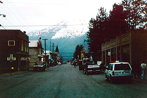
Laden with rucksacks and pulling a handcart each, we walk the streets with
their wooden sidewalks in dim moonlight. Because of our baggage, we
identify with the prospectors who arrived here a hundred years ago. All
that's missing are a pickaxe and a shovel. |
|
|
| |
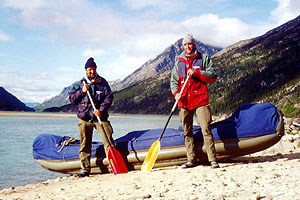
The next morning, our first impressions are swiftly shattered as the streets are filled with trucks and busses, and the shops and squares are teeming with tourists. Here, we organize the next leg of our trip, which leads along the Chilkoot Trail to Lake Bennett, where we're planning to start our journey down the river in our inflatable canoe. Our original plan to transport our boat to Bennett by train falls through, as the train isn't running this year due to jurisdiction disputes between the Canadians and
the Americans. Since there are no roads all the way to Bennett, we get a driver to take our boating gear to Log Cabin. Having hiked to Log Cabin, we will then have to haul it along the rail tracks ourselves for the final 12 kilometers to Bennett. That same evening, we set off on our 5-day hike over
the mountains with only light baggage. We keep coming across the remains of huts and belongings that were left behind by the adventurers during their ascent. We can't believe that, a hundred years ago, people even tried to drag cast-iron stoves over the mountains on foot. |
| |
|
|
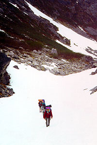
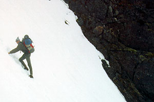
Our way leads through the valley's young birch woods until we reach the
tree line and the first snowfields. It gets steeper, and we pass lots of
scree before we reach the final ascent, the famous >>Golden Stairs<<. |
|
| |
Here, a hundred years ago, a few enterprising individuals dug steps into
the snow and charged the adventurers for using them. In those days, the Canadian Mounties did checks up here, to make sure the adventurers had
enough equipment and supplies with them, because at the beginning of the
Gold Rush there was absolutely no infrastructure in the hinterland. That's
also why many people ended up tackling the exhausting ascent several times,
trying to get all their belongings across the mountains bit by bit. |
|
|
| |
|
|
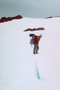
Today, there is still a small Canadian station at the top of the ridge, which is now mainly being used by mountain rescue teams. From here on, the
ground is relatively even, and our way leads across vast expanses of snow
that might harbour crevices. The snow is already quite soft, we often sink
in up to our thighs and our boots are soon wet. The >>Happy Camp<<, too, one
of the excellent resting places, is still covered in deep snow, and we
can't find a dry place for our tent. |
|
| |
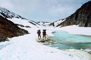
The lower we get, the more often we see flowing water. This is the water
that we are going to follow for the next 3.500 kilometers. |
|
|
|