| |
 |
| |
|
| |
M
e n u e |
| |
|
| |
|
| |
|
| |
|
|
| |
 |
|

East Greenland - In the tight grip of the pack ice |
|
| |
|
|
Author: Markus
Ziebell, Photos: Markus Ziebell, Translated by: Carmen Chaplin
This trip was made in Juli/August 2007
Dieser Reisebericht ist auch in deutscher Sprache verfügbar. Bitte folgen Sie diesem Link |
| |
In the tight grip of the pack ice
An account of a four week solo kayak tour through the Scoresbysund in East
Greenland |
|
|
| |
At a length of 314 kilometers, the Scoresbysund is the largest fjord in the
world. I intend to circumnavigate 600 kilometers of the Milne Land. |
| |
When I am dropped off full of expectation at the heliport of Ittoportomiut
on the morning of July 25th after a 24 hour journey, I have more than nine
months of preparation behind me. As all my attempts to find suitable
travelling companions have failed, my anticipation is mixed with a certain
amount of suspense. I wonder whether I am equal to the challenges ahead.
But I have trained hard during the last months, and I am determined to
succeed here. |
| |
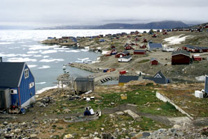
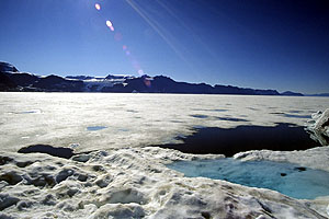
In front of Scoresbysund, with its 500 inhabitants the second largest town
in East Greenland, lies a dense ice belt. The east wind often pushes ice
from the Atlantic into the fjord, which blocks shipping.
. |
|
|
| |
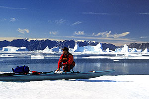
During the approach, I can already see that the entire bay is covered by
thick drift ice. Just before leaving Germany, I had received an email from
Karina, who works for the local >Nanu - Travel<, that ice conditions are
difficult at present. Once here, though, I am given hope that this may
change at any moment. And sure enough, by next morning the ice has opened
up a bit. So I pack my gear early, take the 7 - shot pumpgun in case of
polar bears, and pick up my boat from the port authorities. My sea - kayak
already started its journey 6 weeks ahead of me, on a Royal Arctic Line
cargo ship at Aarlborg. Finally, everything is ready, and I embark on the
first leg, making my way through the maze of ice floes. Because of my low
sitting position, it is hard for me to see which channels go on and which
ones end in a dead end after a few meters. Again and again, I get out of
the boat when possible and up onto the ice floes, and that's how I first get acquainted with pack ice and all its obvious faults. After only a few
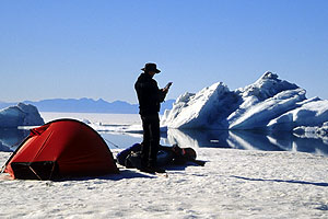
hours, I pitch my camp just before the small settlement of Kap Hope. While I'm eating, a family of hunters joins me on my rocky coast. Hidden behind a
stone rampart, they lie in wait for seals, which rest on floes here. For
most of East Greenland's inhabitants, hunting for seals, musk oxen and whales still constitutes a large part of their living. Even though the
Inuit wear mostly modern clothing today, the kill is still fully utilized
in the traditional way. It only takes about an hour before a loud bang
tears the silence, and father and son rush to recover a fully grown ringed
seal by boat. Thus, this family now has enough meat for a few days. I,
however, stick to my spaghetti for the next few weeks, which I enrich with
a little ready - made Pemmikan. For even without seal blubber I need about
4.000 calories a day.
|
| |
|
|
When on day three the sun finally comes out , I'm in high spirits. I am
right on schedule and feel totally fit.
|
|
| |
After crossing the Hurry Fjord, the ice becomes more open and consequently,
my daily performance increases. To realize my plan to circumnavigate the
Milne Land I need to paddle about 23 kilometers a day. That sounds quite
easy-going. But bearing in mind all the things that might happen on a 600
kilometer trip, my ideal daily target is 30 kilometers, just to be on the
safe side. On the third day, I finally tackle the planned fjord crossing
south towards the Volquards - Boons - Kyst. That morning, almost 40
kilometers still separate me from the impressive mountain range in the
south. Numerous glaciers plunge down the steep slopes directly into the
sea. Because of the clear air and this tremendous, 2.000 meter high wall,
the coast seems within my grasp after the shortest time. But it still takes
hours before I reach the first ice fields that herald the coast. |
| |
|
|
A closed ice sheet that stretches to the horizon bars my way. Too thin for
walking on, and much too thick for paddling through.
|
|
| |
DThe ice fields grow ever denser, and about 6 kilometers from the coastline
I run into an uninterrupted flat layer of sea ice. I get a better view from
a higher ice ridge, and discover that the coast is inaccessible. I search
the horizon for a way west. Without success ! The barometer promises stable
weather conditions, so I decide to pitch my camp on a 30 meter long floe
that appears strong enough. |
|
|
| |
I am aware of the fact that this very area is the habitat of the polar
bear. I spend a predictably uneasy night, with one ear permanently at the
wall of the tent, and one hand on the loaded gun. I don't hear from the
King of the Arctic that night, but I am treated to a loud creaking and
bubbling when a small iceberg turns in close proximity to my floe. In the
morning, I'm relieved that the floe hasn't been moved by the current, or
been surrounded by pack ice, but I discover that a strip approx. 5 meters
wide has broken off. At this point, I remember the stories by Fritdjof
Nansen, who spent weeks sitting on ice floes that kept breaking underneath
his feet. After breakfast, it takes me hours to move along the edge of the
ice hand over hand, and I try to follow countless channels towards the
west, only to find out that there is no getting through. As I discover
later, the closed sheet of ice stretches northward for about 50 kilometers,
to a latitude north of Kap Leslie. Around noon, I notice that a weather
front is approaching from the south. Since I don't fancy spending another
night on the ice, I head back towards Jameson Land. A few hours later, the
first slight gusts of wind start blowing across the water, pushing me on
from behind. Today, I only reach a suitable beach after 13 hours in the
kayak. The next morning, my body is still so tense from the frustrations
and 60 kilometers of the previous day, that I take a break for a day. |
|